San Gorgonio Pass Water Supply Sources
San Gorgonio Pass Water Supply Sources
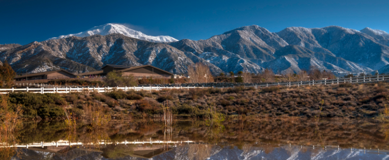
The San Gorgonio Pass is an elevated, narrow landform situated between the San Bernardino Mountains to the north and the San Jacinto Mountains to the south. It connects the San Bernardino Valley on the west with the Coachella Valley on the east and straddles two major watersheds.
Local Geography
The western portion of the region is drained primarily by Little San Gorgonio Creek and Noble Creek, tributary to the Whitewater River in the Colorado River Basin. A smaller area drains to the San Jacinto River, which flows into Lake Elsinore.
Water Supply Sources
The region relies on a combination of local and imported supplies to serve residents, businesses, farms, and institutions.
Groundwater
Groundwater begins as rain and snow in the surrounding mountains, replenishing underground aquifers. The area averages 17.5 inches of precipitation annually.
Imported Water
The State Water Project (SWP) conveys water from Northern California through the California Aqueduct. The San Gorgonio Pass Water Agency, one of 29 SWP contractors, holds an allocation of 17,300 acre-feet annually, selling this supply to local purveyors.
The SWP is the nation’s largest state-built water and power development system. It delivers water to 27 public agencies and serves more than 26 million Californians through reservoirs, canals, tunnels, pumping stations, and power plants.
Learn more: www.swc.org | water.ca.gov/swp
Recycled Water
Treated wastewater is reused for irrigation, industrial purposes, or recharge into local basins. Several agencies in the Pass Area are in different stages of planning or implementing recycled water programs.
Local Runoff
Runoff from Edgar Canyon and Banning Canyon contributes to groundwater recharge, supplementing local supplies.
Stormwater Capture
Stormwater capture has potential as a new supply during major storm events, but requires significant land for percolation basins and related infrastructure.